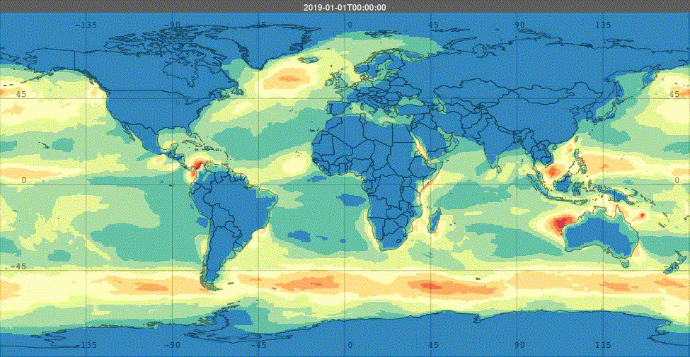
ISO 9223 Steel Corrosion Rate
Interactive map with scientific data analysis, point lookup, and detailed environmental information
Map Information
In ISO 9223, the corrosion rate for steel is classified based on the atmospheric corrosivity categories. These categories describe the annual loss of material thickness in micrometers per year (µm/year) for uncoated carbon steel exposed to the environment.
Data Legend
Location Analysis
Technical Specifications
Background
In the fields of protective coatings and corrosion management, two ISO standards serve as foundational references: ISO 12944-2 and ISO 9223.
- ISO 12944-2: guides the selection of coating systems based on the environmental conditions a structure is exposed to.
- ISO 9223, on the other hand, offers a structured framework for classifying and quantifying atmospheric corrosivity—a critical metric for estimating material degradation and service life.
ISO 9223 defines corrosivity categories from C1 (very low corrosivity) to CX (extreme corrosivity). These categories are determined using a dose-response function based on four key environmental parameters. Below is the ISO9223 Steel dose response function used in generation of this map.
$$ r_{corr} = 1.77 \cdot P_D^{0.52} \cdot exp({0.02 \cdot RH + f_{St}}) + 0.102 \cdot S_D^{0.62} \cdot exp(0.033 \cdot RH + 0.040 \cdot T) $$ where,
$$ f_{St} = 0.150 \cdot (T - 10) \quad \text{if } T < 10^\circ\mathrm{C} $$
$$ f_{St} = -0.054 \cdot (T - 10) \quad \text{if } T \geq 10^\circ\mathrm{C} $$
where
- $r_{corr}$ - First year corrosion rate ($um/year$)
- $T$ = Annual Mean Temperature (C)
- $RH$ = Annual Mean Relative Humidity (%)
- $P_D$ = Annual average $SO_2$ deposition ($mg/(m^2d)$)
- $S_D$ = Annual average $Cl^-$ deposition ($mg/(m^2d)$)
The reader is referred to the ISO9223 standard for further dose response functions.
Data Sources
We use the following sources to build our atmospheric corrosivity data:
- NOAA Integrated Surface Hourly – Temperature and humidity via hourly or sub hourly reporting, with global resolution.
- Government of Canada - Historic Climate Database - Reliable temperature and humidity data for stations in Canada, including rural locations.
- EPA Airnow Program - Temperature, humidity and pollutant data.
- National Data Buoy Center - Temperature, humidity data for off-shore sites.
- EPA National Atmospheric Deposition Program (NADP) – Gold-standard for wet SO₂ deposition.
- NASA Giovanni & MERRA-2 – Chloride and sulfate reanalysis datasets.
We build our own temperature, humidity, sulfate, and chloride deposition maps using the above sources, and then apply the dose response function to score. Those maps are also available to the users of the ISO9223 application.
Chlorides (2024 Update)
The most common question we're asked is about how we compute chlorides in our model. In 2024, we created a new model that we believe captures the dynamics of wet candle deposition for ISO9223 better than our prior maps. This new model incorporates:
- Wind Multiplier — Wind magnitudes.
- Wind Direction - Vector-averaged wind directions.
- Bathymetry/DEM Integration — combining onshore elevation and offshore depth for precise coastal and inland decay modeling.
- Refined Distance-to-Coast Decay — applying steeper PM10-style decay near the coast and PM2.5-style gradual decay inland.
- Terrain Ruggedness Adjustment — using the Ruggedness Index (RIX) with reduced penalties for complex landscapes.
- Peninsula Detection Logic — adding a multiplier in areas with negative coastal distances, low elevation, moderate temperatures, and high humidity.
This is on top of the starting point for our chloride estimation, which is:
- MERRA-2 SSDP: Sea Salt Dry Deposition all bin sizes
- MERRA-2 SSWT: Sea Salt Wet Deposition all bin sizes
All these variables can be accessed through NASA's Giovanni System. The data is monthly, here's a view of five years rolling monthly SSSMASS25 (sea salt surface mass concentration for PM2.5).
No science is perfect, but we think our updated model better reflects the dynamics of chloride deposition. For validation, we compare to the ISOCORRAG and MICAT datasets, however even those canonical data sets have questionable wet-candle deposition figures (for instance, MICAT includes some non-observational estimated wet-candle deposition numbers).
Excessive Localized Emissions
Our model best suits ambient environments. It may not apply where Excessive Localized Emissions occur—examples include:
- Proximity to coal-fired power plants
- Urban zones with concentrated chloride sources (e.g., road salts, bird waste)
These require local measurements or alternate modeling approaches. See CBOT™ IoTSensor for localized corrosion rate measurements.
Data Distribution Analysis
These histograms show the distribution of pixel values across the entire raster dataset, helping you understand the range and frequency of different measurements.